Floodplain Info-Catoctin Creek
September 2024 Floodplain UPDATES
On Sep 24, 2024, at 13:54, Andrews, Jordan <[email protected]> wrote:
Good Morning Tip,
The County will be paying for the elevation certificates/surveys, so we are eager to make sure everyone who is given the opportunity takes them up on the offer.
The County will also be paying for/conducing the LOMR at the conclusion of the project.
Regards,
Jordan Andrews, CZO
Planner
Town of Purcellville
[email protected]
221 S. Nursery Ave;
Purcellville, VA 20132
(540) 751-2331
______________________________________cut line
On Sep 23, 2024, at 14:56, Andrews, Jordan <[email protected]> wrote:
Good Afternoon Gary and Tip,
My apologies for the delay, Mondays are always a bit of a catch up day. I’m not sure if the County’s contact will be someone from Dewberry or DTCI or other department, but it will be included in their letter. On our end, Town contacts will include myself and likely a member of Engineering. We had requested a copy of the letter once they were being sent out, so if the board itself doesn’t hear directly from the County, we will forward once we have it.
Hopefully we have a nicely crafted and explanatory letter in our hands soon, but we may have been out ahead of it. I appreciate your work and hope to be able to collaborate to make sure we take full advantage of the opportunity for homeowners.
Regards,
Jordan Andrews, CZO
Planner
Town of Purcellville
[email protected]
221 S. Nursery Ave;
Purcellville, VA 20132
(540) 751-2331
___________________________________________________________cut line
On Sep 20, 2024, at 8:13 AM, Andrews, Jordan <[email protected]> wrote:
Here is some informational FAQs from FEMA on Elevation Certificates(EC) that Andrea has gathered together.
As I mentioned, I believe the County will be contacting homeowners soon.
I don’t know that Parcel A would get a EC, as my understanding from below is that they are specific to structures.
Jordan Andrews, CZO
Planner
Town of Purcellville
[email protected]
221 S. Nursery Ave;
Purcellville, VA 20132
(540) 751-2331
___________________________________________
What is a FEMA Elevation Certificate?
FEMA Elevation Certificate
View Larger (PDF)
A FEMA elevation certificate (sometimes called a Flood Certificate) is a tool provided by the National Flood Insurance Program (NFIP) to determine the likelihood of your house being damaged in a flood. It is a technical document which must be prepared by a registered land surveyor. It documents the elevation of your house in relation to the elevation published on the Flood Insurance Rate Map.
This information is then used by your insurance agent to determine whether or not a property owner needs to obtain flood insurance on his or her property and what the insurance premium will be.
How Does The Surveyor Create A FEMA Flood Elevation Certificate?
Flood Insurance Rate Map – Covington, GA.
View Larger (PDF)
To complete an Elevation Certificate, the surveyor must first locate the property on the appropriate Flood Insurance Rate Map. The rate maps for a community generally show the base flood elevations and the flood zones. The surveyor will determine the flood elevation for your house.
Next, the land surveyor will use GPS or run levels from a bench mark having a known elevation to your house and establish a temporary bench mark on your property. The surveyor then gathers elevation information for your house which includes the elevations of each floor, the highest and lowest natural elevations of the ground at your house, and the lowest elevation of a deck or steps which attach to your house, and other required elevations. The surveyor will take pictures of the four sides of your house. Then, the surveyor compiles this elevation data in the Elevation Certificate.
Measuring Lowest Elevation of Equipment
This information will then be used by your insurance agent to determine whether or not the property owner needs to have flood insurance and how much it will cost. Generally, the higher the house is above the flood elevation, the lower the insurance premium will be for that house. It is the prerogative of the lender to require flood insurance even if your house is not in a flood zone. If this is the case you will probably qualify for a preferred risk policy which will have very low rates.
Flood Insurance Rate Maps are updated from time to time, and the flood elevation for a house may change over time based on local land use and on the technology that is used to plot the flood limits. Oftentimes, people may be paying for flood insurance based on old rate maps. It may benefit you to have a professional land surveyor verify that your FEMA Elevation Certificate is based on the most current Flood Insurance Rate Maps.
Do I Need A FEMA Elevation Certificate?
Measuring Lowest Adjacent Grade
Lenders will often require flood insurance when a refinance occurs, or when your loan is otherwise due for a review. The lender wants to protect their investment and will insist that you purchase flood insurance. They will purchase it for you, but it is usually cheaper if you contact your own insurance agent for a premium quote.
If you are selling your home it pays to be proactive and provide a FEMA Elevation Certificate to the prospective buyer as an inducement to purchase your home. If there is a slight risk of flooding the buyer can choose to obtain a quote before making an offer on the house.
Likewise, if you are buying a house, make it a condition of the contract that a FEMA Elevation Certificate be provided and that, if required, insurance can be obtained that does not exceed a certain amount.
How Much Does A FEMA Elevation Certificate Cost?
The most important factors affecting the cost of a FEMA Elevation Certificate are as follows:
- The number of structures on the property that need to be insured. Each structure must have a separate FEMA Elevation Certificate.
- The size and complexity of the structure.
- The ability to obtain GPS readings under heavy tree canopy around the house.
August 2024 Floodplain UPDATE:
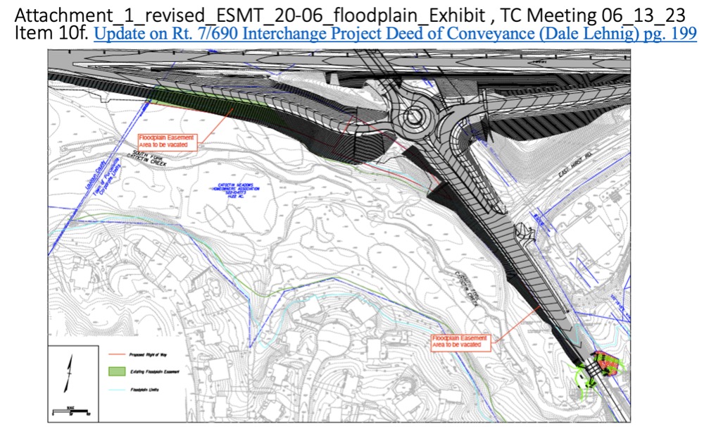
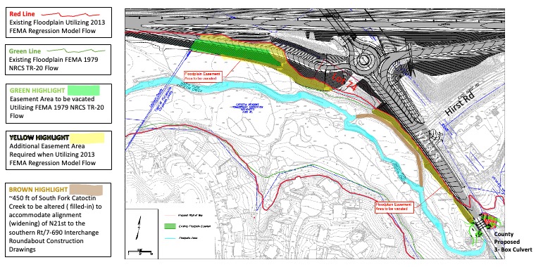
Loudoun County has released its 3rd Submission of the Floodplain Alteration Study for the Rt7/690 Interchange which may impact a number of residences and properties along the South Fork Catoctin Creek up and down stream from N21st Street in Purcelville.
If your property is listed on the Floodplain Area Tabulation table shown on Sheet 1 of the FPAL 2022-0020 Third Submission you may consider contacting the Town of Purcellville Engineering Department for further details about how this study may impact your property.
Community ID: 510231
County Name: Loudoun County
NFIP Participating Community: Yes
CRS Participating Community: No
https://www.purcellvilleva.gov/
Floodplain Administrator
Summer R. Wilkes, MURP, CNU
Director of Planning and Community Development / Zoning Administrator
221 S. Nursery Ave.
Purcellville, VA 20132
Direct 540-751-2342
Town Cell 540-326-1866
and / or
You may also consider reaching out to the Department of Conservation and Recreation Floodplain Department in Richmond for professional guidance how this study may or may not impact your property, as well.
Click FPAL 2022-0022 Third Submission 06-27-2024 to be transferred to Loudoun County's contractor (preliminary) study.
and / or
Senator Russet Perry's Office
Jessie Williams Reynolds
Chief of Staff
Office of State Senator Russet Perry
c: 757-871-0516
[email protected]
++++++++++++++++++++++++++++++++++++++++++++++++++++++++++++++++++++++++++++++++
On Oct 16, 2023, at 4:55 PM, Board <[email protected]> wrote:
Dear Mayor, Vice Mayor, and Council
The purpose of our letter is to energize the Town to begin their required municipal process of addressing the impact of the floodplain modeling presented to the Town several months ago as it relates to the CMHOA members properties along and within the vicinity of the South Fork Catoctin Creek and in particular west of N21st within the Catoctin Meadows Common Open Space.
The Town is long overdue in starting their municipal process and the longer the Town delays action to address the floodplain threat the greater the liability becomes for the Town, taxpayers, and homeowners.
The Board understands the municipal process begins with Town notification to FEMA of any delineation of base flood elevation (BFE) changes.
It is worth noting the ordinance requires the Town to submit to FEMA data and information necessary maintain the Floodplain Insurance Rate Map (FIRM) within six months after such data and information becomes available to the Town (January 2020).
Objectively, the Town has had this data and information on the South Fork Catoctin Creek base flood elevation (BFE) changes for more than six months (see the attached chronology of details).
Furthermore, we find it egregious that the Town continues to actively work with County on strategies to vacate these floodplain easements, especially considering the fact the Town has failed to comply with its own ordinance and the easements are underrepresented on the County’s land development applications to the Town.
We appreciate your positive response and further action to address the Town’s failure to comply with Article 12 of the Town’s zoning ordinance, which sole purpose is to prevent the loss of life and property to Town citizens.
Respectfully,
Board of Directors
Catoctin Meadows Homeowners Association
Attachments, Chronology of Details
May 07, 2020_RPA-987-LC, ESMT-20-06 Land Development Application, Parcel A
November 07, 2022_Loudoun County Floodplain Alteration (FPAL 2022-0020)
January 10, 2023_ BoS FGOEDC Report
February 13, 2023_Staff Report_PC_7_690March 2023, Rt7/690 CMHOA Project Update Floodplain
June 05, 2023, Town Email to CMHOA Member
_______________________________________________________________________________________________
|
On 21 Oct 2023 - 18:11, President CMHOA Wrote: From Tip Stinnette <[email protected]> |
|
Chris and Town Council— This strategy is consistent with the staff report recommendation to Council on Feb 16: “Regardless of whether the 7/690 Project is constructed or not, Town Staff recommends that the Town update the floodplain mapping, using the best available data. Communities should reasonably use this information where BFE’s increase and floodways are revised to ensure the health, safety and property of their citizens are protected.” In short, the first one to the white board, in this case FEMA, sets the terms of any subsequent debate between Town and County on floodplain model flow-rates and proximate causes and impacts. We appreciate your service and hope you will consider the Staff recommendation to initiate an update to the floodplain mapping before any construction begins. On 10/18/23 9:05 AM, Email form Vice Mayor Chris Bertaut wrote: Ron: Is the issue driving the CMHOA's request to the Town that they conduct a floodplain study that the County (and the Town for that matter) have been resisting telling FEMA that the floodplain has changed. Is it also the case that the way to inform FEMA is to do a floodplain study that covers the area in question and send the results to FEMA in the form of a Letter of Map Revision, or a Conditional Letter of Map Revision. The County has already said that they intend to redo their floodplain study AFTER they build 7/690. Isthe strategy is to put study data in the hands of FEMA before they build 7/690?
|
________________________________________________________________________________________________
| File | Uploaded | |
|---|---|---|
Pages
- Home
- Selling Your Home?
- Contact Us
- Governing Documents
- Board of Directors
- Architectural Control Committee
- Lot 74, 601 N.21st St LC-BoS Owners
- Floodplain Info-Catoctin Creek
- SpottedLanternFlySubcommittee
- Town of Purcellville Residents Info
- Town Charter, Codes, and Zoning
- Town Zoning Ordinance Update
- 2025 Town Official Zoning Map
- Town 2030 Comprehensive Plan
- 2013-2018 Rt7/690 Interchange Docs
- Rt7-690 Interchange Project Info
- Rt 7 West Safety-Operational Study
- Western Loudoun Recreation Center
- Subcommittee NaturePreserveParcel-A
- RT 7 / 690 CONSTRUCTION ACTIVITY